


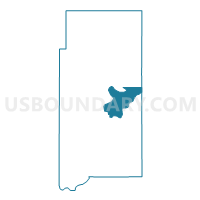
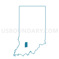
NORTH HALBERT, Martin County, Indiana
About
Outline

Summary
| Unique Area Identifier | 579707 |
| Name | NORTH HALBERT |
| County | Martin County |
| State | Indiana |
| Area (square miles) | 15.27 |
| Land Area (square miles) | 15.02 |
| Water Area (square miles) | 0.26 |
| % of Land Area | 98.33 |
| % of Water Area | 1.67 |
| Latitude of the Internal Point | 38.70156410 |
| Longtitude of the Internal Point | -86.74190470 |
Maps

Graphs
Select a template below for downloading or customizing gragh for NORTH HALBERT, Martin County, Indiana


Neighbors
Neighoring Voting District (by Name) Neighboring Voting District on the Map
- EAST MEMPHIS, Martin County, IN
- MITCHELTREE, Martin County, IN
- NORTH CENTER, Martin County, IN
- SOUTH HALBERT, Martin County, IN
- SPICE VALLEY SOUTH, Lawrence County, IN
- WEST MEMPHIS, Martin County, IN
Top 10 Neighboring County Subdivision (by Population) Neighboring County Subdivision on the Map
- Spice Valley township, Lawrence County, IN (2,423)
- Center township, Martin County, IN (1,654)
- Halbert township, Martin County, IN (1,631)
- Mitcheltree township, Martin County, IN (624)
Top 10 Neighboring Place (by Population) Neighboring Place on the Map
Top 10 Neighboring Unified School District (by Population) Neighboring Unified School District on the Map
Top 10 Neighboring State Legislative District Lower Chamber (by Population) Neighboring State Legislative District Lower Chamber on the Map
Top 10 Neighboring State Legislative District Upper Chamber (by Population) Neighboring State Legislative District Upper Chamber on the Map
Top 10 Neighboring 111th Congressional District (by Population) Neighboring 111th Congressional District on the Map
Top 10 Neighboring Census Tract (by Population) Neighboring Census Tract on the Map
- Census Tract 9507, Lawrence County, IN (6,877)
- Census Tract 9503, Martin County, IN (3,800)
- Census Tract 9501, Martin County, IN (2,669)